NASA는 인터넷 홈페이지를 통해 수년 동안의 촬영 및 현상 작업을 통해 얻은 ‘지구 예술 프로젝트’ 사진들을 공개했다.
26일 영국 더 타임스 등을 통해 보도된 후 해외 네티즌들 사이에서 큰 화제를 낳고 있는 ‘위성 사진’은 현대 예술 작품이 아니라,
지구 기후 변화 및 환경 연구를 위해 미국항공우주국이 지난 1999년부터 2006년까지 지구 표면을 랜드샛-7 위성 등이 ‘지구 관측 프로젝트’를 통해 촬영한 사진들이다.
태양빛을 받아 찬란하게 빛나는 남극의 얼음,
하얀 눈이 덮인 히말라야 산봉우리,
사하라 사막 한 가운데의 오아시스 등
지구 곳곳의 모습을 담은 사진들로서,
고도 수백 km에 위치한 위성이 촬영한 아시아, 유럽, 남극, 아메리카 등 전 세계 지구 표면의 모습이다.
이 사진들은 한 폭의 수채화 혹은 현대 추상미술 작품을 연상시킨다고 해서,
NASA 측은 이 프로젝트를 ‘지구 예술’로도 부르고 있는데,
이 사진들은 색깔 보정 및 이미지 필터링 등을 거쳐 만들어졌기 때문에,
화려한 색감, 추상적 구도를 가지고 있어서 마치 현대 예술 작품과 비슷한 분위기를 연상시키고 있다.
(사진 : NASA의 ‘지구 예술 프로젝트’ 사진들 / NASA 지구 관측 프로젝트 홈페이지 자료사진)
NORTH AMERICA
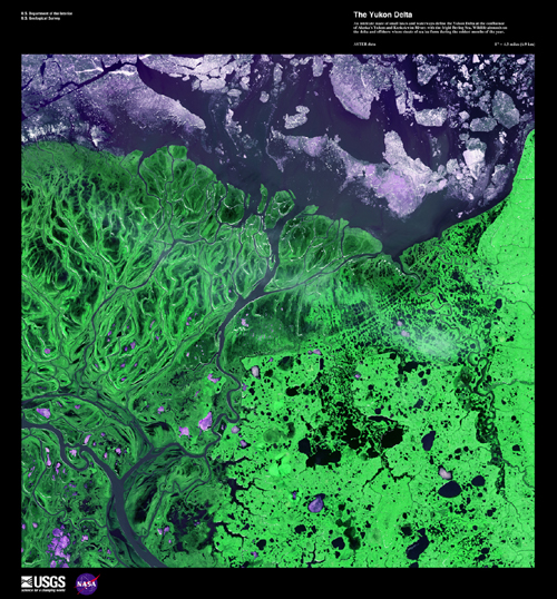
The Yukon Delta
Image taken 5/26/2002 by ASTER
An intricate maze of small lakes and waterways define the Yukon Delta at the confluence of Alaska's Ukon and Kuskokwim Rivers with the frigid Bering Sea. Wildlife abounds on the delta and offshore where sheets of sea ice form during the coldest months of the year.
This image can be found on ASTER Path 103 Row 76, center: 63.03 N, 163.62 W.
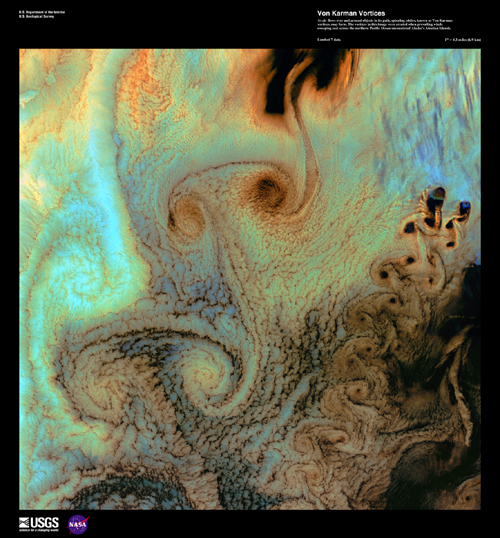
Von Karman Vortices
Image taken 7/4/2002 by Landsat 7
As air flows over and around object!!s in its path, spiraling eddies, known as Von Karman vortices, may form. The vortices in this image were created when prevailing winds sweeping east across the northern Pacific Ocean encountered Alaska's Aleutian Islands.
This image can be found on Landsat 7 Path 79 Row 23-24, center: 53.1 N, 170.4 W.
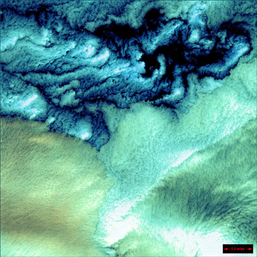
Aleutian Clouds
Image taken 6/16/2000
These cloud formations were seen over the western Aleutian Islands. Their color variations are probably due to differences in temperature and in the size of water droplets that make up the clouds.
The Aleutian Clouds can be found on Landsat 7 WRS Path 91 Row 23, center: 53.10, 170.97.
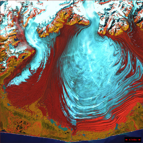
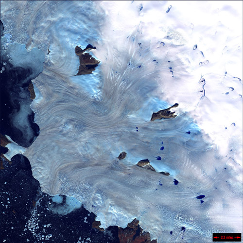
Malaspina Glacier
Image taken 8/31/2000
The tongue of the Malaspina Glacier, the largest glacier in Alaska, fills most of this image. The Malaspina lies west of Yakutat Bay and covers 1,500 sq. MI (3,880 sq. km).
Malaspina can be found on Landsat 7 WRS Path 63 Row 18, center: 60.10, -141.78.
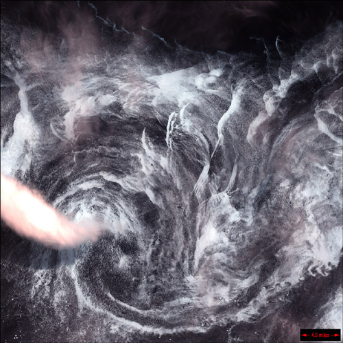
Whirlpool in the Air
Image taken 5/14/2001
This image shows a spinning formation of ice, clouds, and low-lying fog off the eastern coast of Greenland.
This Whirlpool can be found on Landsat 7 WRS Path 232 Row 16, center: 62.86, -40.89.
Greenland Coast
Image taken 9/3/2000
Along Greenland's western coast, a small field of glaciers surrounds Baffin Bay.
This portion of Greenland's Coast can be found on Landsat 7 WRS Path 20 Row 7, center: 74.71, -57.07
Yellowknife Wetlands
Image taken 7/3/2001
Extensive wetlands lie near the town of Yellowknife, near the Great Slave Lake in northern Canada. The shallow lakes seen in this image have formed in grooves in the landscape that were carved by glaciers during the last Ice Age.
Yellowknife Wetlands can be found on Landsat 7 WRS Path 45 Row 16, center: 62.86, -111.97.
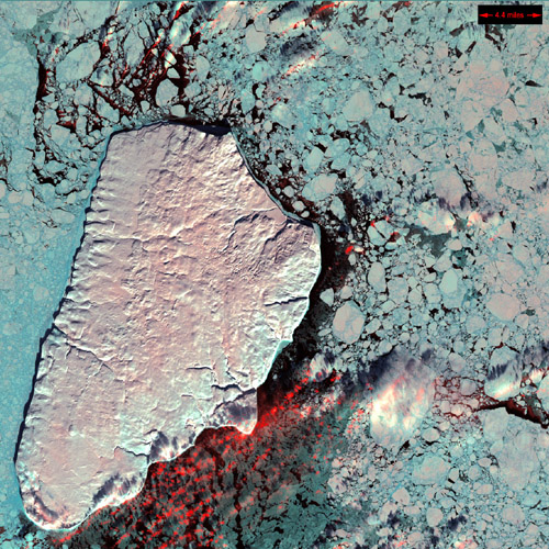
Akpatok Island
Image taken 1/22/2001
Akpatok Island lies in Ungava Bay in northern Quebec, Canada. Accessible only by air, Akpatok Island rises out of the water as sheer cliffs that soar 500 to 800 feet (150 to 243 m) above the sea surface. The island is an import!!!ant sanctuary for cliff-nesting seabirds. Numerous ice floes around the island attract walrus and whales, making Akpatok a traditional hunting ground for native Inuit people.
Akpatok Island can be found on Landsat 7 WRS Path 15 Row 18, center: 60.10, -67.62.
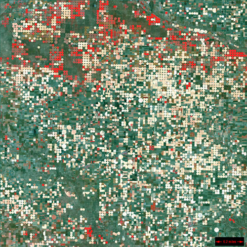
Garden City, Kansas
Image taken 9/25/2000
Center pivot irrigation systems create red circles of healthy vegetation in this image of croplands near Garden City, Kansas.
Garden City can be found on Landsat 7 WRS Path 30 Row 34, center: 37.48, -100.51.
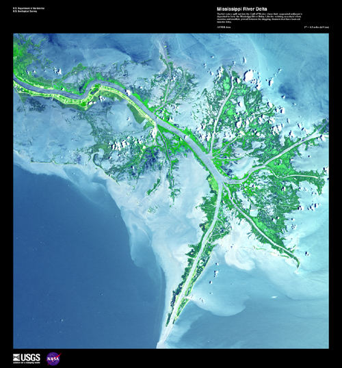
Mississippi River Delta
Image taken 5/24/2001 by ASTER
Turbid waters spill out into the Gulf of Mexico where their suspended sediment is deposited to form the Mississippi River Delta. Like the webbing on a duck's foot, marshes and mudflats prevail between the shipping channels that have been cut into the delta.
This image can be found on ASTER Path 21 Row 40, center: 29.45 N, -89.28 W.
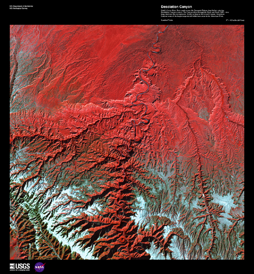
Desolation Canyon
Image taken 12/31/2000 by Landsat 7
Utah's Green River flows south across the Tavaputs Plateau (top) before entering Desolation Canyon (center). The Canyon slices through the Roan and book Cliffs - two long, staircase-like escarpments. Nearly as deep as the Grand Canyon, Desolation Canyon is one of the largest unprotected wilderness areas in the American West.
This image can be found on Landsat 7 Path 37 Row 32, center: 40.3 N, 110.4 W.
Florida Everglades
Image taken 2/5/2000
Spanning the southern tip of the Florida Peninsula and most of Florida Bay, Everglades National Park is the only subtropical preserve in North America. It contains both temperate and tropical plant communities, including sawgrass prairie, mangrove and cypress swamps, pinelands, and hardwood hammocks, as well as marine and estuarine environments. The park is known for its rich bird life, particularly large wading birds, such as the roseate spoonbill, wood stork, great blue heron, and a variety of egrets. It is also the only place in the world where alligators and crocodiles exist side by side.
The Everglades can be found on Landsat 7 WRS Path 15 Row 42, center: 26.00, -80.43.
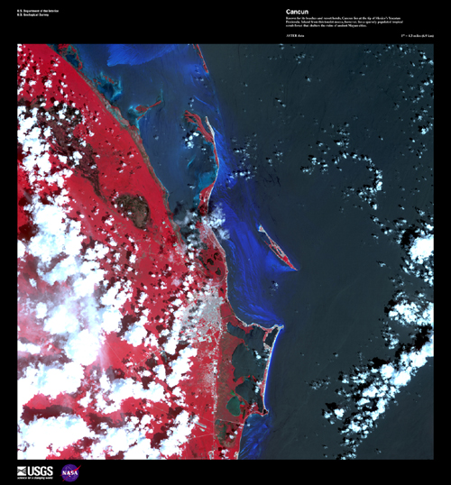
Cancun
Image taken 9/28/2000 by ASTER
Known for its beaches and resort hotels, Cancun lies at the tip of Mexico's Yucatan Peninsula. Inland from this tourist mecca, however, lies a sparsely populated tropical scrub forest that shelters the ruins of ancient Mayan cities.
This image can be found on ASTER Path 18 Row 45, center: 21.25 N, 86.79 W.
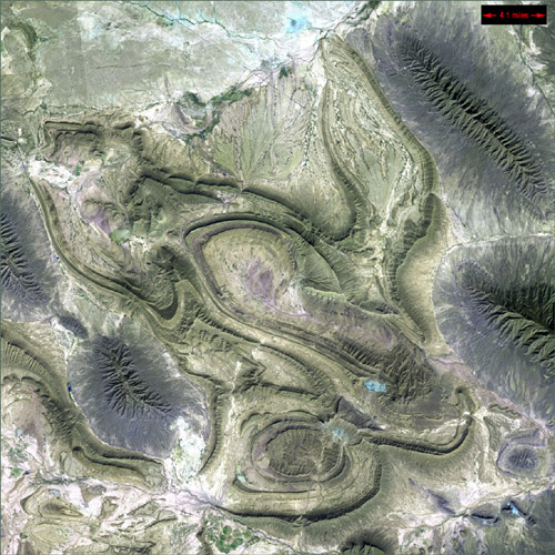
Coahuila, Mexico
Image taken 11/28/1999
This desolate landscape is part of the Sierra Madre Oriental mountain range, on the border between the Coahuila and Nuevo Leon provinces of Mexico.
Coahuila can be found on Landsat 7 WRS Path 28 Row 42, center: -26.00, -100.52.
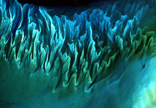
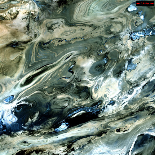
Ocean Sand, Bahamas
Image taken October 29, 2000
Though the above image may resemble a new age painting straight out of an art gallery in Venice Beach, California, it is in fact a satellite image of the sands and seaweed in the Bahamas. The image was taken by the Enhanced Thematic Mapper plus (ETM+) instrument aboard the Landsat 7 satellite. Tides and ocean currents in the Bahamas sculpted the sand and seaweed beds into these multicolored, fluted patterns in much the same way that winds sculpted the vast sand dunes in the Sahara Desert.
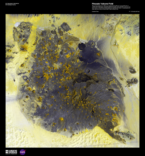
Pinacate Volcano Field
Image taken 12/5/2002 by Landsat 7
The pockmarked terrain of Pinacate National Park in Mexico's Sonora Province is evidence of a violent past. Among hundreds of volcanic vents and cinder cones are rare maar craters, formed when rising magma met underground water to create pockets of steam that blew nearly circular holes in the overlying crust.
This image can be found on Landsat 7 Path 37 Row 38, center: 31.7 N, 112.9 W.
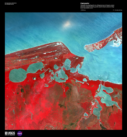
Campeche
Image taken 5/2/2002 by ASTER
Named after the ancient Mayan Province of Kimpech, the state of Campeche comprises much of the western half of Mexico's Yucatan Peninsula. Rivers in southern Campeche drain into the immense Terminos Lagoon, the entrance to which is protected by a long barrier island, Isla Del Carmen.
This image can be found on ASTER Path 21 Row 47, center: 18.57 N, 91.97 W.
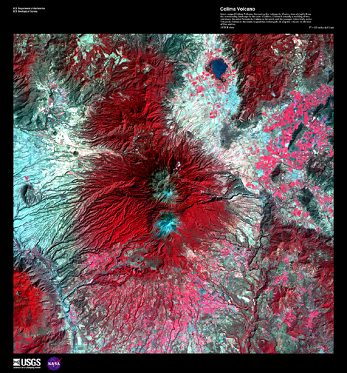
Colima Volcano
Image taken 2/6/2003 by ASTER
Snow-capped Colima Volcano, the most active volcano in Mexico, rises abruptly from the surrounding landscape in the state of Jalisco. Colima is actually a melding of two volcanoes, the older Nevado de Colima to the north and the younger, historically more active Volcan de Colima to the south. Legend has it that gods sit atop the volcano on thrones of fire and ice.
This image can be found on ASTER Path 29 Row 46, center: 19.57 N, 103.60 W.
ASIA & THE MIDDLE EAST
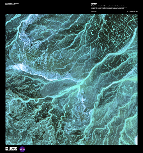
Jordan
Image taken 5/17/2001 by ASTER
Meandering wadis combine to form dense, branching networks across the stark, arid landscape of southeastern Jordan. The Arabic word "wadi" means a gully or streambed that typically remains dry except after drenching, seasonal rains.
This image can be found on ASTER Path 173 Row 39, center: 30.93 N, 37.03 E.
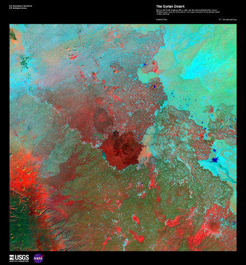
Syrian Desert
Image taken 11/6/2000 by Landsat 7
Between the fertile Euphrates River valley and the cultivated lands of the eastern Mediterranean coast, the Syrian Desert covers parts of modern Syria, Jordan, Saudi Arabia, and Iraq.
This image can be found on Landsat 7 Path 173 Row 37, center: 33.2 N, 37.3 E.
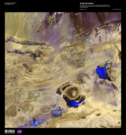
Great Salt Desert
Image taken 4/25/2001 by Landsat 7
Like swirls of paint on an enormous canvas, shallow lakes, mudflats, and salt marshes share the sinuous valleys on Iran's largely uninhabited Dasht-e Kavir, or Great Salt Desert.
This image can be found on Landsat 7 Path 163 Row 36, center: 34.6 N, 53.2 E.
Dasht-e Kevir
Image taken 10/24/2000
The Dasht-e Kevir, or valley of desert, is the largest desert in Iran. It is a primarily uninhabited wasteland, composed of mud and salt marshes covered with crusts of salt that protect the meager moisture from completely evaporating.
Dasht-e Kevir can be found on Landsat 7 WRS Path 162 Row 36, center: 34.62, 54.71.
Iraqi Emplacement
Image taken 1/24/2001
In an area north of the city of Al-Basrah, Iraq, which borders Iran, a former wetland has been drained and walled off. Now littered with minefields and gun emplacements, it is a staging area for military exercises.
This emplacement can be found on Landsat 7 WRS Path 166 Row 39, center:30.31, 47.36.
Konari, Iran
Image taken 2/2/2000
The Mand River and the small town of Konari nestle in the Zagros Mountains in western Iran.
Konari can be found on Landsat 7 WRS Path 163 Row 40, center: 28.87, 51.62.
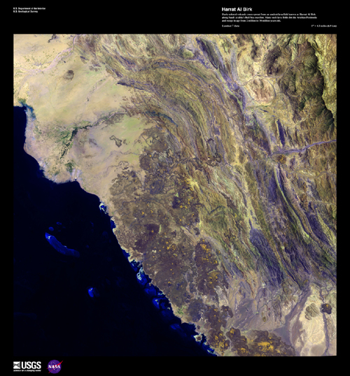
Harrat Al Birk
Image taken 4/18/2003 by Landsat 7
Dark-colored volcanic cones sprout from an ancient lava field known as Harrat Al Birk along Saudi Arabia's Red Sea coastline. Many such lava fields dot the Arabian Peninsula and range in age from 2 million to 30 million years old.
This image can be found on Landsat 7 Path 168 Row 47, center: 18.8 N, 41.5 E.
Sulaiman Mountains
Image taken 4/28/2001
The Sulaiman Mountains are a major geological feature of Pakistan and one of the bordering ranges of the Indian subcontinent.
The Sulaiman Mountains can be found on Landsat 7 WRS Path 152 Row 37/38/39, center: 31.75, 69.37.
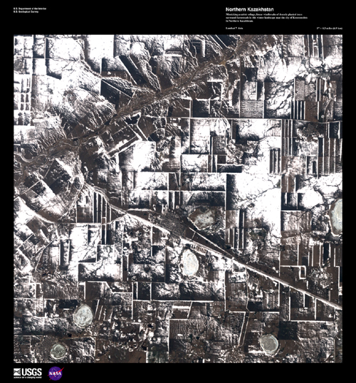
Northern Kazakhstan
Image taken 4/14/2002 by Landsat 7
Mimicking a cubist collage, linear windbreaks of densely planted trees surround farmsteads in this winter landscape near the city of Komsomolets in Northern Kazakhstan.
This image can be found on Landsat 7 Path 161 Row 23, center: 53.1 N, 62.9 E.
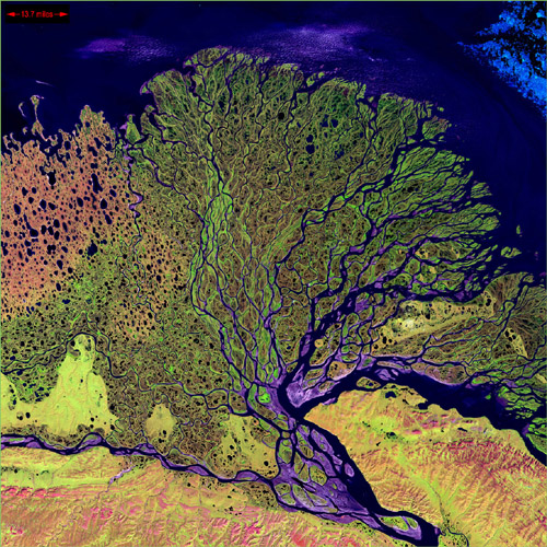
Lena Delta
Image taken 7/27/2000
The Lena River, some 2,800 miles (4,400 km) long, is one of the largest rivers in the world. The Lena Delta Reserve is the most extensive protected wilderness area in Russia. It is an import!!!ant refuge and breeding grounds for many species of Siberian wildlife.
The Lena Delta can be found on Landsat 7 WRS Path 131 Row 8/9, center: 72.21, 126.15.
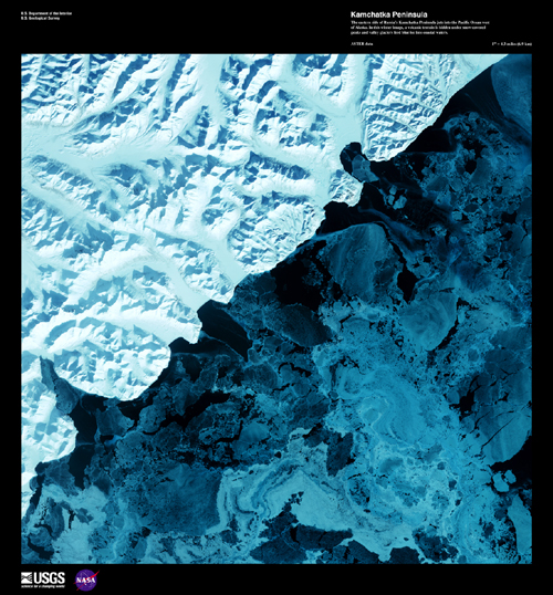
Kamchatka Peninsula
Image taken 2/17/2002 by ASTER
The eastern side of Russia's Kamchatka Peninsula juts into the Pacific Ocean west of Alaska. In this winter image, a volcanic terrain is hidden under snow-covered peaks and valley glaciers feed blue ice into coastal waters.
This image can be found on ASTER Path 96 Row 18, center: 60.03 N, 167.68 E.
Karman Vortices near Broutona
Image taken 6/5/2000
These Karman vortices formed over the islands of Broutona, Chirpoy, and Brat Chirpoyev ("Chirpoy's Brother"), all part of the Kuril Island chain found between Russia's Kamchatka Peninsula and Japan.
Broutona can be found on Landsat 7 WRS Path 103 Row 27/28, center: 46.03, 149.54.

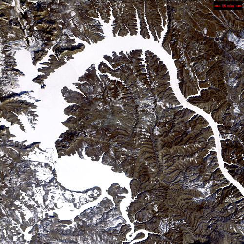
Dragon Lake, Siberia
Image taken 12/19/1999
Nicknamed "Dragon Lake," this body of water is formed by the Bratskove Reservoir, built along the Angara River in southern Siberia, near the city of Bratsk. This image was acquired in winter, when the lake is frozen.
Dragon Lake can be found on Landsat 7 WRS Path 136 Row 21, center: 55.92, 102.93.
Mayn River, Siberia
Image taken 10/25/2000
The Mayn River, seen here with what is thought to be a portion of the Anadyr River, flows through the far northeastern corner of Siberia.
The Mayn River can be found on Landsat 7 WRS Path 96 Row 15, center: 64.23, 170.37.
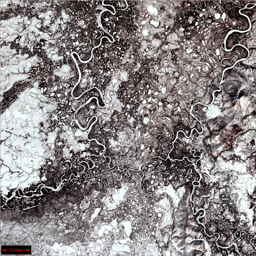
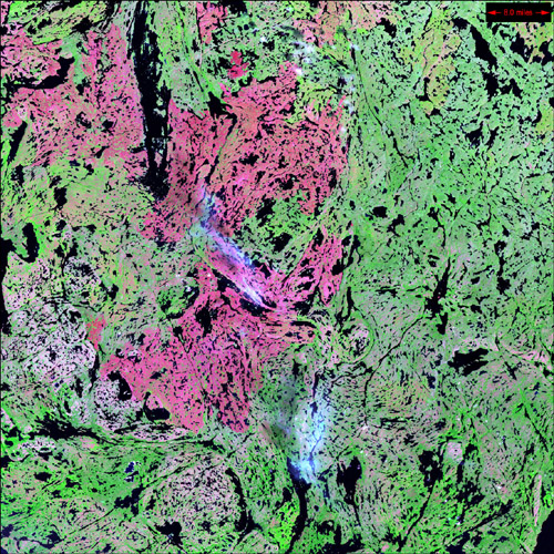
Alluvial Fan, China
Image taken 5/2/2002 by ASTER
A vast alluvial fan blossoms across the desolate landscape between the Kunlun and Altun mountain ranges that form the southern border of the Taklimakan Desert in China's XinJiang Province.
This image can be found on ASTER Path 143 Row 34, center: 37.43 N, 84.30 E.

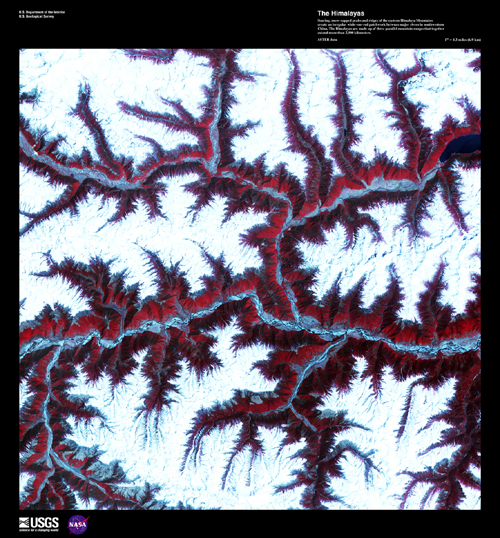
The Himalayas
Image taken 2/17/2002 by ASTER
Soaring, snow-capped peaks and ridges of the eastern Himalayas Mountains create an irregular white-on-red patchwork between major rivers in southwestern China. The Himalayas are made up of three parallel mountain ranges that together extend more than 2900 kilometers.
This image can be found on ASTER Path 136 Row 39, center: 29.93 N, 93.62 E.
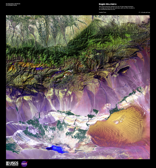
Bogda Mountains
Image taken 9/1/1999 by Landsat 7
The Turpan Depression, nestled at the foot of China's Bogda Mountains, is a strange mix of salt lakes and sand dunes, and is one of the few places in the world that lies below sea level.
This image can be found on Landsat 7 Path 141 Row 30, center: 43.2 N, 89.8 E.
Edrengiyn Nuruu
Image taken 8/13/1999
The Edrengiyn Nuruu forms a transition zone between the Mongolian steppes to the north and the arid deserts of northern China to the south.
Edrengiyn Nuruu can be found on Landsat 7 WRS Path 136 Row 29, center: 44.61, 98.03.
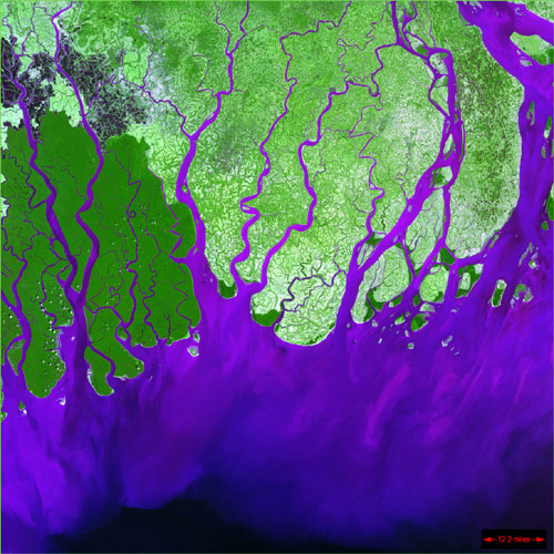
Ganges River Delta
Image taken 2/28/2000
The Ganges River forms an extensive delta where it empties into the Bay of Bengal. The delta is largely covered with a swamp forest known as the Sunderbans, which is home to the Royal Bengal Tiger.
The Ganges River Delta can be found on Landsat 7 WRS Path 137 Row 44, center: 23.12, 90.37.
'천체 망원경 > ┃ 지구 환경' 카테고리의 다른 글
| 오로라 (0) | 2008.01.04 |
|---|---|
| 소금호수 속 스피루리나가 지구를 살린다? (0) | 2007.12.20 |
| 지구종말(핵전쟁 시나리오) (0) | 2007.09.20 |
| 우주 인류로의 진화 (0) | 2007.09.10 |
| 그리스 산불 재해 (0) | 2007.08.30 |
